I. URBAN DESIGN PRINCIPLES. These principles are based on a shared understanding of the current character and condition of Phoenix as follows:
• Phoenix is a new City reflecting a diversity of architectural styles.
• Phoenix is a large metropolis in a valley of small towns and neighborhoods. Phoenix has been developed largely in small pieces occupying a vast land area. Despite its size, the separation of those pieces remains as a barrier to the goals of community and a higher quality of life. We should seek to diminish these forces of separation in the form of our City by fostering an attitude of neighborliness within our urban fabric. Each development should enhance its neighborhood and relate to the valley as a whole.
• Phoenix is a desert City - our unique environment should be celebrated.
• Phoenix is currently a City with a priority for travel by private vehicles. New development should foster the creation of environments with a priority for pedestrians. The average pedestrian moves at about four mph and views (and uses) the environment in a detailed fashion.
• Phoenix has the opportunity to become one of the great cities of the 21st Century. Our cultural history includes the prehistoric civilization that once inhabited this valley. When we acknowledge this fact, we become one of the few cities in the world to have such a heritage. When we ignore this resource, we become just another large American city.
A. Contextualism. Every development has a relationship to its setting. Positive relationships can be achieved by examining the next largest (and smallest) context of the site. Ignoring the context can often assure poor relationships.
NOTE: Each project should have a context plan.
1. The size, character and setting of proposed protects should relate to their specific contexts and functions of adjacent streets and pedestrian networks. Buildings should be oriented to public rights-of-way as well as additional internal circulation systems.
2. Each project should reflect the broader environmental context of Phoenix as a desert City and respect the value of our scarce resources, the abundance of sunshine and the richness of our natural resources and amenities.
3. The natural environment of our desert context contains critical extremes. The opportunity of a harmonious response exists when these factors are understood and addressed in the design. Those projects which acknowledge this tend to thrive; those which ignore this fact tend to be foolish.
4. New development should incorporate building materials and technology that are compatible with the Southwest setting and that are responsive to the climate of this region.
5. Each project should identify at the outset of its design whether its specific context is an oasis or an arid setting. Deviating from the general character of the site context is generally not appropriate, particularly in the landscape.
B. Amenity/Comfort. Settlements in the desert generally occur in an "oasis" setting which is a respite from the extreme of the larger area context. A development in an arid setting requires design features to aid human comfort. It is important to understand that urban conditions such as paved areas and buildings generating reflected heat create aridity and require mitigating design features which enhance habitability.
1. Promote human comfort by providing shaded areas, courtyards, public and private walkways, colonnades and other areas as site amenities.
2. Create developments for the ease of pedestrians both on and off site.
3. Promote the creation of public and semi-public places at both large and small scales to encourage a sense of community.
4. Recognizing our desert setting, create a sense of place that respects nature and utilizes natural and man-made materials and devices.
5. Protection from the sun and heat is a priority between late April and September, while access to the sun is a priority from October to mid April.
6. Encourage separation of pedestrians and automobiles.
7. Promote night time uses of sites with secure, well lighted amenity zones and programmed activities.
C. Visual Interest. An environment that contains a harmonious balance of various forms and materials can be visually interesting. Too much variety or too much uniformity can lack visual interest. New development should seek to preserve and enhance this basic human need.
1. Incorporate architectural and landscape elements at the pedestrian level.
2. Maintain a human scale by creating variation of the urban form.
3. Recognize the interest created by both the repetition and changes in various project patterns from window openings to paving designs.
4. Promote a diversity of architectural styles.
5. Integrate arts and crafts creatively into the built environment.
6. When a project occurs in a visually rich context, its form, materials, orientation and detailing should incorporate the assets offered by its setting.
7. When a project occurs in a setting devoid of visual interest, it should seek to provide variety of forms and texture.
D. Activity. Environments that provide a variety of choices for people are generally active settings for people to gather. This fosters a sense of community when a visit can serve multiple needs in a setting that provides safety, security, and activity.
1. Encourage mixed-use developments so as to provide increased opportunities for informal and planned activities beyond the typical 9 a.m. to 5 p.m. work hours.
2. Promote design which will increase opportunities for activities both within the project boundaries and between existing adjacent developments and neighborhoods.
3. Where feasible, encourage design of single-usage facilities to accommodate retail and other uses at the pedestrian level to encourage activity and use.
E. Clarity and Convenience. An environment that is easy to understand will usually also be convenient for the people who use it. That is not to say complexity must be avoided. Complexity can offer excitement, but not at the expense of routine accessibility of the general public.
1. Environments should be created that are understandable and help orient the user and the general public.
2. Developments should be convenient to and accessible by persons with physical limitations and disabilities.
3. Developments should derive their basic ordering from the underlying geometry of City streets and the north/south, east/west orientation it implies. This will assist the ready comprehensibility of the City. Individual projects should relate to existing streets and canals, except where creative design establishes a more successful relationship to new streets, pedestrian walkways, or major open spaces.
4. Sites should be planned to respect existing natural and manmade landmarks and to create landmarks for the ease of public recognition.
5. Protect major vistas and panoramas that give special emphasis to open space and mountains.
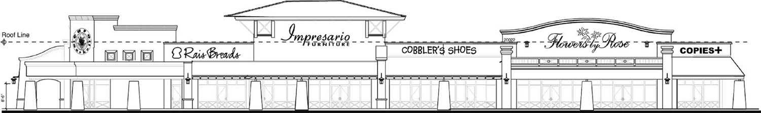
6. Design project signage and environmental graphics at a scale that provides clarity to the pedestrian as well as the automobile and does not result in visual clutter.
F. Character/Distinctiveness. Every project should strive to enhance the unique character of its neighborhood. Without limiting the creative opportunities for the specific project, the development should help make its neighborhood more distinctive.
1. Each development should contribute to the character identified for each village and the specific character for neighborhoods within each village.
2. Promote neighborhood identity by planning elements that reinforce the landscape and built character of the area.
3. The character and environments should be designed at a human scale as well as within its neighborhood identity.
G. Definition of Space. Streets, parking lots, buildings and landscape are the major elements that define the special qualities of our environment. Organize them to foster a setting supportive to the pedestrian as well as the driver.
1. Relate the size, character and setting of proposed projects to the functions of adjacent streets and pedestrian networks. Buildings should be oriented to the public rights-of-way and close to pedestrian movement.
2. The areas immediately adjacent to buildings should be designed to integrate with surrounding landscape and pedestrian walkways. Shaded courtyards, walkways, cloisters, trellises, colonnades and public art are encouraged for consideration into the design to define space.
3. In an effort to create safe pedestrian walkways on highly traveled public rights-of-way, a buffer area should separate the sidewalk from the street curb.
4. On-street parking should be encouraged in village core business areas to further protect the pedestrian zone from vehicular traffic.
H. Views. City dwellers and visitors alike appreciate being reminded of the beauty of their environment. Protecting views of it assist in fostering appreciation of our environment, as well as allowing the environment to aid in orienting people spatially within Phoenix.
1. Protect major vistas and panoramas that give special emphasis to open space, mountains and special manmade or nature landmarks.
2. Promote the creation of views both from within a project and from the adjacent streets and neighborhoods into the project. Consider the access to views of both the project users and the general public.
3. Create opportunities for incorporating individual projects into the patterns and sequence of views that exist within an area, neighborhood or urban village.
I. Variety/Contrast. Variety of site and building design helps to create interest within an urban area. Coupled with attention to creating environments for human activities, such variety fosters goals of creating identifiable neighborhoods and of encouraging creative development.
1. Promote variety and diversity of building and site design within a context of urban and architectural continuity.
2. Create environments that encourage a number of specific activities fronting the street, court or plaza at ground level to provide variety at a human scale.
J. Scale and Pattern. Ultimately, all developments must relate to the human scale. Patterns help humanize development.
1. A large structure should contain elements which transition to the human scale, particularly near the ground.
2. If a development is larger (or smaller) than its adjacent physical context, the design should provide transitional elements at the perimeter to integrate it with its surroundings.
3. The variation of scale, pattern and texture of building and landscaping elements is encouraged to create a more visually interesting project. The variety should be "readable" at the pedestrian scale as well as from a distance (skyline).
4. The proportion between the height of a building and the width of the street and setback determine the basic urban form. If the intent of the design is urban in character, the height should be greater and the setback less.
5. Building should be designed to reveal or express their primary patterns of use and entry. This will not only assist comprehensibility, but also achieve a desirable variety.
K. Cultural History. Our City is a crossroad for various cultures which can thrive together or be ignored completely. While Phoenix may appear to be a very new City, there are many layers of history upon which this valley has been built. These remnants contribute to our heritage and to the vitality of this City. Honoring this heritage enriches our community. To ignore this decreases the opportunity and significance of the development.
1. Enhance and promote the historical and cultural qualities that are inherent and distinctive to the area.
2. Identify and incorporate as much as possible the particular history of each site. Whenever possible, historically significant buildings and their related landscape setting should be retained and restored, or put to adaptive reuse with respect to their cultural value, and their connection with the City’s heritage.
3. Encourage and develop spaces for activities that promote the local and historic characteristics of the people of Phoenix. These events and activities should take advantage of the Southwest climate and other natural amenities.
4. Building design should be responsive to the existing context - including historical patterns and cultural expectations.
L. Sonoran Preserve. The City Council approved Sonoran Preserve Master Plan provides public amenities that contain large areas of scenic and sensitive lands. The preservation of significant hillsides, addressing the relationship to desert washes and the native vegetation, creates a unique setting for surrounding development, an attractive identity, and an amenity for all Phoenix citizens.
1. Where rezoning occurs adjacent to the Sonoran Preserve, encourage development on the lower slopes below the ten percent slope line, consistent with the general plan, to maintain the preserve as a visual amenity for all citizens and to maintain connectivity between mountains within the same range.
2. Maintain physical access to public preserve lands and a sense of public ownership.
3. Prohibit gated communities adjacent to the Sonoran Preserve that preclude public access to the preserve, except that gated subdivisions will be allowed after assurance that the sixty percent open edge treatment is provided and connectivity in accordance with the Sonoran Preserve Master Trail Plan is maintained.
4. Development design should take advantage of the proximity of the Sonoran Preserve in subdivision layout and site design.
5. Minimize damage in the Sonoran Preserve by providing controlled access points including trails, parking areas and recreation amenities.
6. Encourage commercial uses that compliment and assist in the active or passive enjoyment of the Sonoran Preserve lands near primary and secondary access points to the preserve.
7. Use the desert wash system for storm water management, allowing for the natural function of the floodplain and desert washes where feasible, based on engineering parameters and public safety.
8. Construct bridges and culverts to minimize impacts to washes.
9. The wash system can provide a place for trails, within trail easements above the wash banks, or below the wash banks in approved areas and can provide physical or visual connections to the Sonoran Preserve and wildlife habitat.
10. Use desert vegetation landscaping for low water use, survivability, and to maintain the existing sense of place.
11. Minimize the impact of invasive plant species.
II. CITY-WIDE DESIGN REVIEW GUIDELINES. The design review guidelines indicate specific standards of implementation and are categorized as Requirements (R), Presumptions (P), or Considerations (C).
A. Site Design/Development.
1. Desert Preservation.
1.1. Development should minimize the removal of existing healthy Sonoran Desert vegetation (trees over 4" caliper in diameter) and cacti over 3' in accordance with City Native Plant Preservation Standards (Table 1). If removal is necessary, mature trees and cacti should be salvaged and utilized on site. (P)
Rationale: Sonoran desert vegetation is a slow growing, scarce, valuable resource which provides a unique character and sense of place to this region which should be preserved.
PROTECTED NATIVE PLANTS shall mean cacti, which are three (3) feet, or greater in height and trees which are four (4) inches or greater in caliper of the following species:
4.1.5. Wall signs that are placed above the roofline should not exceed eighty percent (80%) of the width or height of the architectural feature to which they are attached. (P)
Rationale: Wall signs should not create a crowded appearance and should be in harmony with the architecture of the building.
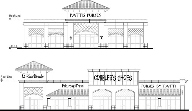
4.1.6. Wall signs placed on a peaked roof should be structurally integrated into the appearance of the roof, without visible bracing. (P)
Rationale: Signs mounted on a peaked roof should appear to be a part of, rather than distinct from, the roof.
4.1.7. Ground signs placed closer to the building than the width of the sign should not exceed the height of the building, or should be designed to appear to be an integral part of the architecture of the building. (P)
Rationale: Ground signs placed close to a building should be complementary of the building’s design and scale to avoid the appearance of being crowded against the building.
4.1.8. One wall sign within a commercial center, as defined in Section 202, may exceed thirty feet (30') in height provided that it is architecturally integrated into the building facade. Said sign should be limited to a maximum height of forty feet (40') in height. This provision does not apply to commercial centers that have received a height waiver or are located within a zoning district that otherwise allows buildings to exceed two stories or thirty feet (30') in height. (P)
Rationale: The height of wall signs placed upon architectural features should be in proportion to the height of the building in order to be of a complementary scale.
4.2.1. Sign locations should be integrated within the design of the site and the adjacent streetscape. (P)
Rationale: Signs should be located to provide their functional purpose of communication, and not dominate the building, the site design, or the adjacent streetscape.
4.2.2. Signs and landscaping should be placed so that they are not in conflict when landscaping reaches full maturity. (P)
Rationale: Although landscaping may not initially appear to obscure a sign, it may significantly reduce or eliminate the sign’s effectiveness unless taken into account in the planning process.
4.3.1. Sign placement and materials for multiple tenant occupancies should be delineated in a uniform and consistent manner. (P)
Rationale: Sign content is more comprehensible when it is displayed in a consistent manner and signage causes less visual clutter when it is executed uniformly.
4.3.2. Traffic directionals should be placed to promote safe and efficient traffic flow. (P)
Rationale: Poor placement of signs can confuse motorists and pedestrians and cause potential safely hazards.
4.3.3. Signs should be oriented to promote readability and serve their intended function. (P)
Rationale: Poor orientation reduces the effectiveness of a sign.
E. Specialized Areas.
1. Freeway Mitigation.
1.1. Where noise is, or may be, a detriment to a residence, the following construction techniques should be incorporated:
(A) Noise walls a minimum of eight (8) feet in height should be constructed of 8" minimum thick, concrete masonry units (CMU), or of cast-in-place concrete and contain no openings unless they are above the minimum height required for adequate noise mitigation.
(B) Residential units should be limited to single story for lots abutting the freeway.
(C) Use double-pane windows and solid-core or insulated exterior doors for freeway facings.
(D) Reduce noise transmission through exterior walls by increasing the mass of wall materials, such as an additional layer of gypsum board, or by using staggered wall studs.
(E) Where corner lots back onto the freeway right-of-way, noise walls should "wrap around" and continue along the street side of the lot. (P).
Rationale: Noise studies conducted by HUD have concluded that the listed building techniques will reduce the level of noise that reaches the living space.
1.2. Where lots are to be platted adjacent to an undesigned section of freeway, perimeter walls should be designed to accommodate 12' high walls and constructed to 8' high so that the wall may later be increased in height by a public agency. Need for the additional 4' will be determined after freeway is designed. However, if a council-adopted freeway specific plan calls for a different height, or the developer conducts a noise study, the site-specific data and walls heights will take precedent. (P)
Rationale: Until the freeway design is complete, it is difficult to determine the appropriate height for perimeter walls. However, it has been determined 8' will be adequate for most configurations.
1.3. The number of lots that abut a freeway right-of-way should be minimized. (P)
Rationale: By exposing fewer homes to the negative impacts of the freeway, the neighborhood will be less impacted.
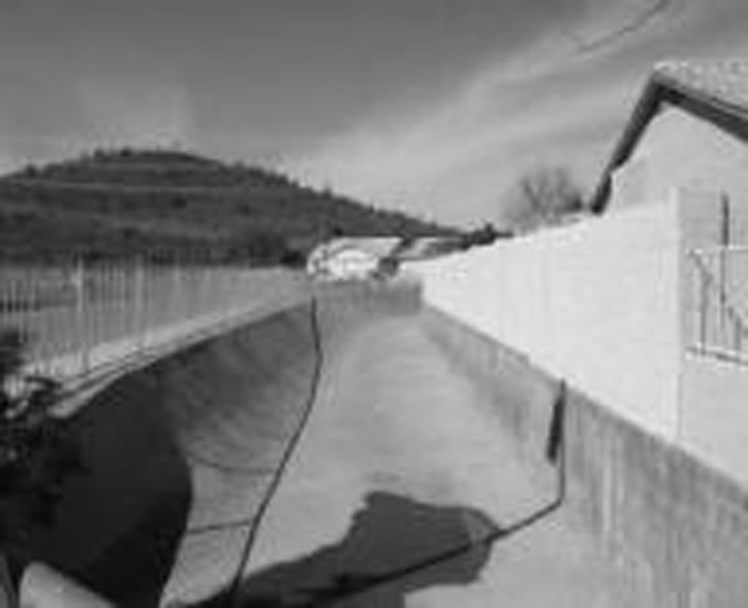
2. Canal Banks. All development in the City of Phoenix on both public and private land adjacent to the Highline, Grand, Arizona, and Western canals which is subject to development review shall comply with the following Canal Bank Design Guidelines. Such development which uses Salt River Project (SRP) canal bank right-of-way or Flood Control District (FCD) Arizona Canal Diversion Channel (ACDC) right-of-way shall also be under a licensing agreement with the City of Phoenix and SRP, and the FCD as required. The Canal Bank Design Guidelines shall control if they conflict with other Citywide design guidelines. The Canal Bank Design Guidelines which are requirements shall control if they conflict with other Citywide development standards. The Canal Bank Design Guidelines which are presumptions and which a developer satisfies shall also-control if they conflict with other Citywide development standards.
2.1. Physical Access.
2.1.a. Public Accessibility.
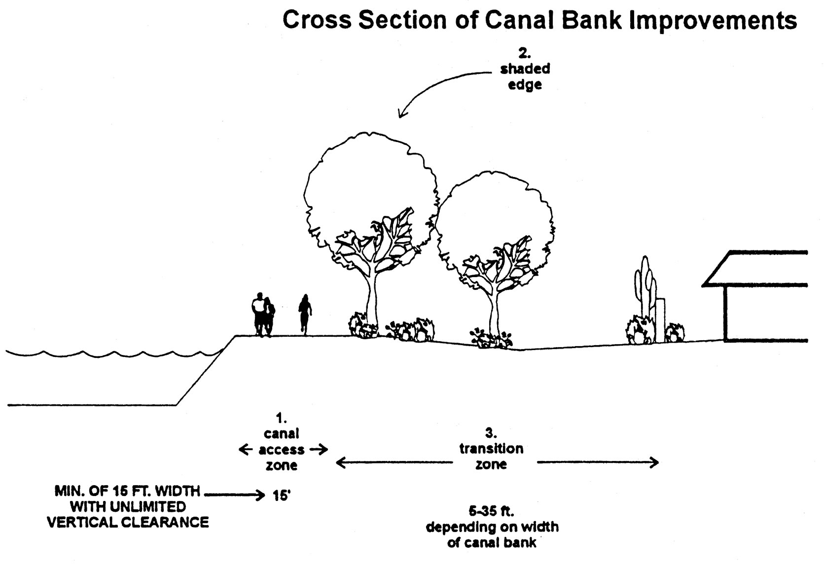
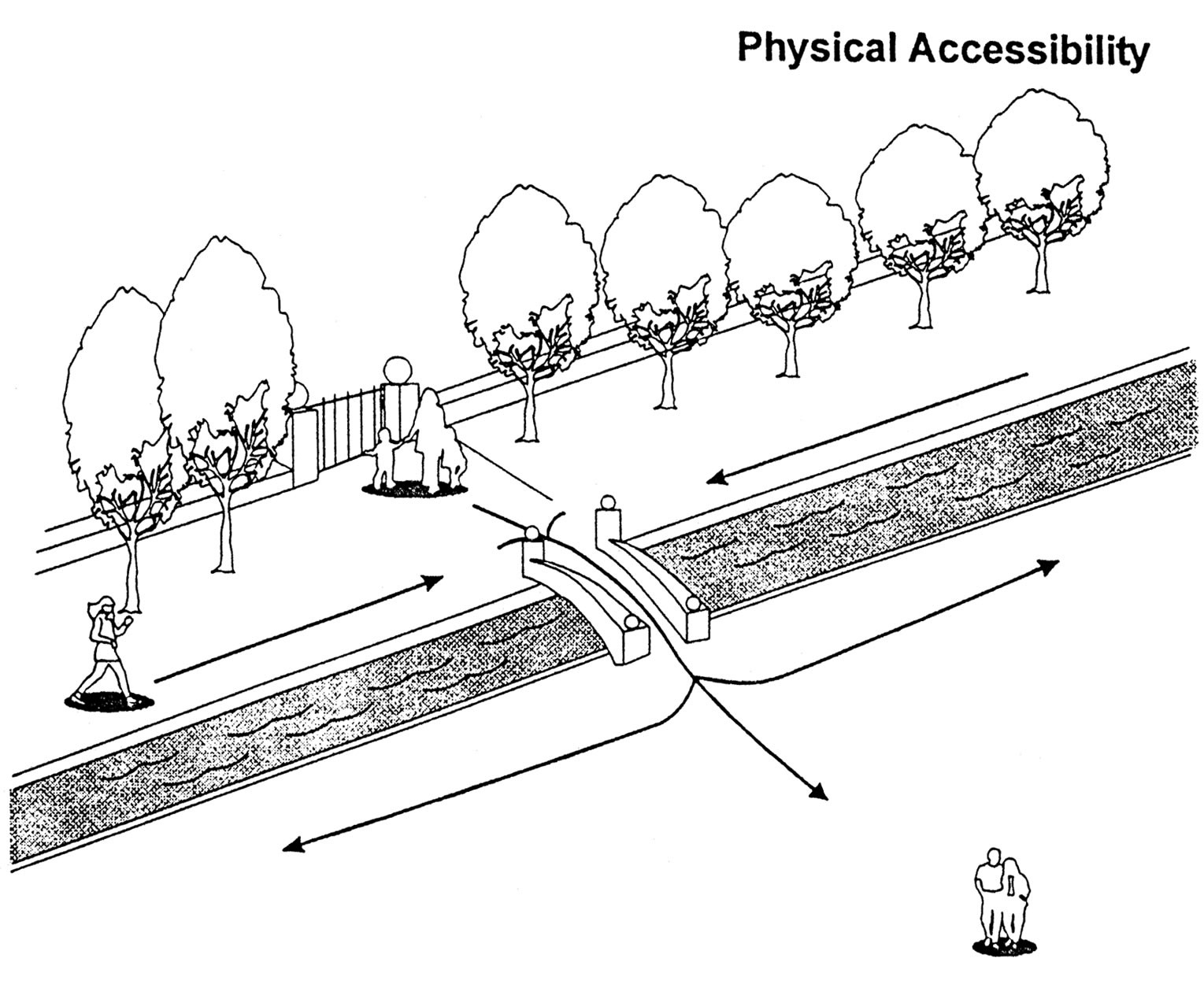
2.1.a.1. No development project shall build closer than fifteen (15) feet to the water’s edge . (R)
2.1.a.2. No development shall restrict access to the canal by building to the water’s edge or erecting a barrier across the canal bank which prevents nonvehicular travel on the canal banks. (R)
2.1.a.3. Developments adjacent to canal banks which provide unrestricted access to their sites from public streets, including retail/commercial, mixed-use, office, research parks and school/park uses, also shall provide public access from canal banks to the site during public hours of operation to promote use of alternative modes of transportation if the canal bank grade is one (1) foot or less above or below the grade of the private property at any point adjacent to the canal bank. Any gates shall be self-closing and self-latching. (R)
2.1.a.4. Developments adjacent to canal banks which provide unrestricted access to their sites from public streets, including retail/commercial, mixed-use, office, research parks and school/park uses, also should provide public access from the canal banks to the site during public hours of operation to promote use of alternative modes of transportation if the canal bank grade is greater than one (1) foot above or below the grade of the private property at any point adjacent to the canal bank. Any gates should be self-closing and self-latching. (P)
2.1.a.5. Where canal access points exist (cul-de-sac, alleys, streets, and utility rights-of-way), adjacent development should provide landscaping on the development’s property. (P)
2.1.a.6. Public pedestrian bridges across the canal are encouraged to link neighborhoods, commercial, recreational, and public uses. (C)
2.1.b. Private Accessibility - For Property Residents/Owners/Tenants.
2.1.b.7. Private yards in residential neighborhoods should be encouraged to have private, self-closing, self-latching pedestrian gate access from the yards to the canals. (C)
2.1.b.8. Residential and non-residential developments with common open space shall provide access to the canal banks with self-closing, self-latching gate(s) which may be keyed for resident/owner/tenant use if the canal bank grade is one (1) foot or less above or below the grade of the private property at any point adjacent to the canal bank. (R)
2.1.b.9. Residential and non-residential developments with common open space should provide access to the canal banks with self-closing, self-latching gate(s) which may be keyed for resident/owner/tenant use if the canal bank grade is greater than one (1) foot above or below the grade of the private property at any point adjacent to the canal bank. (P)
Rationale (3.1.a.1-3.1.b.3): Developments shall not restrict access to the canal by building to the water’s edge . Canal banks should be a primary component of pedestrian (including modes of transportation necessary for people with disabilities), bicycle and equestrian pathways. Public accessibility to the canal system is essential in order to reinforce and preserve the system as a valuable public resource. Accessibility includes not only physical accessibility, but visual and temporal as well. Most people see canals when crossing on arterial streets. This exposure should be enhanced, not diminished.
2.2. Visual Accessibility.
2.2.1. No canal shall be placed underground. (R)
2.2.2. Solid walls above three feet should not be allowed, except to screen open industrial uses, to provide visual access between the canal banks and the adjacent development. (P)
2.2.3. Solid walls abutting the canal bank shall not exceed six hundred sixty (660) feet in length except for open industrial uses. (R)
2.2.4. Not withstanding the provisions of Section 703 of the Zoning Ordinance, wrought iron fences up to eight feet in height shall be allowed. (R)
2.2.5. Significant view corridors of the canals from contiguous public spaces including existing streets and open spaces shall be preserved. (R)
2.2.6. Wherever possible, combine existing views of canals with views of significant natural features (e.g. Camelback Mountain, South Mountain). (C)
Rationale (3.2.1-3.2.6): Views of the canal system should be enhanced and preserved as part of the public realm. Significant historical features of the canals, such as the Pueblo Grande Museum, Park of the Four Waters, and Arizona Falls should be visually integrated into the adjacent canal system. Canals should be placed underground only in cases of property hardship to further the public good; this is consistent with SRP’s policy that canals remain open unless there is a higher public need and the continuity of the system is maintained.
2.3. Landscaping Features within Canal Rights-of-Way.
2.3.1. New trees and shrubs along the canal banks shall be selected for their ability to provide shade and a visual amenity. Modifications to spacing may be required by SRP subject to site specific canal widths or by Development cervices or SRP or the FDC along the ACDC subject to access needs or the slope of the canal bank adjacent to the private property. (R)
2.3.2. Low water use landscape materials shall be used in canal bank development. Landscape materials shall be selected from the Phoenix low water use plant list and SRP’s approved plant list. (R)
2.3.3. An irrigation system shall be designed for canal right-of-way landscaping and installed by the public or private development which is subject to design review, using a municipal water supply or private source. (R)
2.3.4. Landscaping of canal banks shall be designed to avoid drainage into the canals as runoff and into the ACDC as runoff unless the existing and prevailing drainage is already into the ACDC. (R)
Rationale (3.3.1 - 3.3.4): The overall landscape character of canal development should be appropriate to the Sonoran Desert and/or should reflect significant natural areas adjacent to the canals.
2.4.1. Grade separations should be installed at all arterial street crossings to ensure continuity of canal paths while providing maximum safety from vehicular traffic. (C)
2.4.2. The developer shall participate in the installation of one or more of the following safety measures, or an acceptable alternative, based on the determination of the developer’s proportionate share of the cost due to the level of impact of the project on canal bank usage: (R)
(A) Pedestrian activated traffic signal(s) if such a signal meets national standards;
(B) A pedestrian/cyclist safety island within the middle of the road right-of-way,
(C) Clearly marked crosswalk with motorist warning signs,
(D) Vehicular rumble strips to warn oncoming traffic that they are approaching a pedestrian crossing;
(F) Street identification and safe crossing method signage;
These alternatives require approval of the Street Transportation Department
2.4.3. Lighting shall be incorporated in underground pathways, such as those which pass under a street. (R)
2.4.4. No lighting placed within canal right-of-way shall shine onto private residential property. Light intensity shall not exceed one (1) foot candle at the residential property line. (R)
2.4.5. Vegetation height or massing shall not become a safety hazard by restricting visibility within the canal right-of-way. (R)
2.4.6. All alley and street access points perpendicular to the canals should be well lighted and clearly marked. (P)
2.4.7. Placing emergency call boxes which are accessible to wheelchair users and are hearing aid compatible at major arterial crossings is encouraged. (C)
Rationale (3.4.1-3.4.7): Every use of the canal right-of-way should strive to maximize public safety. All potential designs must be analyzed to ensure that the general publics activities are directed either to areas separated from the open channel and overhead electrical system or to areas where safety features are incorporated.
2.5. Power Easements.
2.5.1. All canal uses shall be designed and planned with the coordination of the appropriate power jurisdiction. (R)
2.5.2. No permanent use area (e.g. rest areas) shall be allowed within a fifty (50) foot radius of the center line of any high voltage power tower. (R)
2.5.3. Only trees on the SRP approved plant list shall be planted within the SRP power easement. (R)
2.5.4. Any conductive materials used within power easements shall be properly grounded. (R)
2.5.5. Pedestrians and cyclists should be kept away from power towers with minimum three and one-half (3.5) foot high barrier plantings. (This design must still allow necessary service access.) (P)
Rationale (3.5.1-3.5.5): Of primary importance to the function of the canal system is the ability for SRP to maintain and operate its water delivery service and adjacent power system.
2.6. Adjacent Land Uses.
2.6.1. Parks which abut a canal shall incorporate the canal banks and trails into the design of the park. (R)
2.6.2. Developers of new multi-family housing developments should face the windows and balconies of some units toward the canal. (P)
2.6.3. Some units in a multi-family housing development should be within five (5) feet of the canal right-of-way. (C)
2.6.4. New developments or redeveloped sites with canal frontage should place land uses near or adjacent to the canal which are compatible with the canal system including:
(A) Open space (public or private);
(B) Other public land uses (libraries, cultural facilities, municipal services);
(C) Single-family housing;
(D) Quasi-public land uses (golf courses, resorts, health clubs, research parks);
(E) Retail/commercial (shopping, entertainment, restaurants, cafes, offices);
(F) Multi-family housing;
(G) Mixed-use (office/retail/housing) development. (C)
2.6.5. In order to enhance the visual experience for canal bank users and to promote safety, the frontage along canal banks of adjacent land uses such as storage facilities, parking garages, and outdoor storage should be minimized. (P)
2.6.6. Open industrial land uses and garages shall be screened. (R)
2.6.7. Public spaces within private developments should be located adjacent to the canal in order to achieve integration with the public system of the canal. (P)
2.6.8. Shared use of existing parking lots for canal uses is encouraged. (C)
2.6.9. Parking lots shall be designed so that they do not drain into canals. (R)
Rationale (3.6.1-3.6.9): Canals should be treated as an asset to be integrated with adjacent land use.
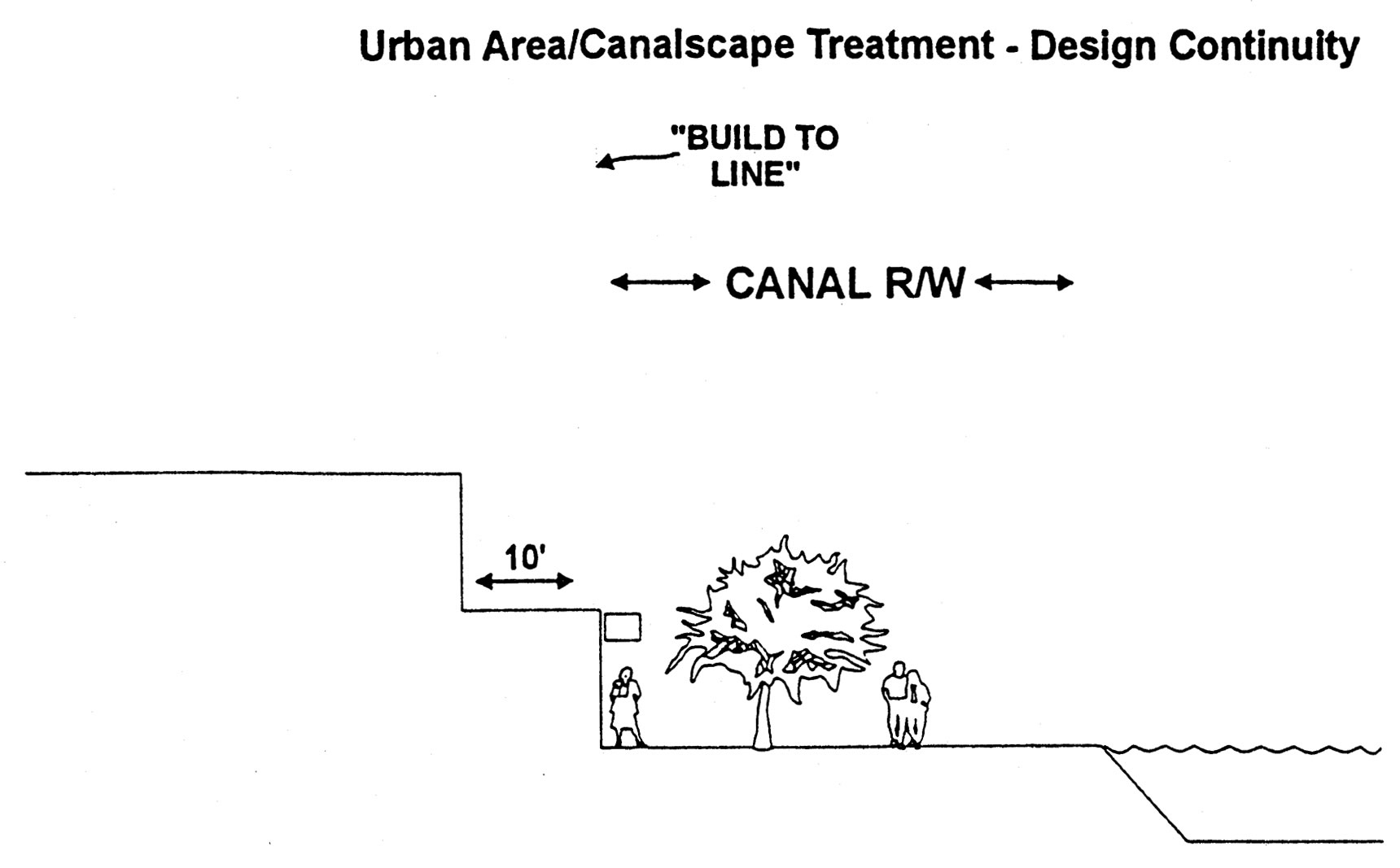
2.7. Urban Area/Canalscape Treatment - Design Continuity. For purposes of this section, an urban area shall be defined as one in which commercial, office, resort/hotel, or public assembly development of four (4) or more stories or a floor area ratio greater than or equal to 1.0, or residential development of twenty-five (25) or more dwelling units per acre abuts a canal bank.
2.7.1. Development which uses canal bank right-of-way at canal waterline edges in urban areas should be marked with curbs, railings, change in grade, change in paving materials, or landscape treatment subject to approval by Salt River Project. (P)
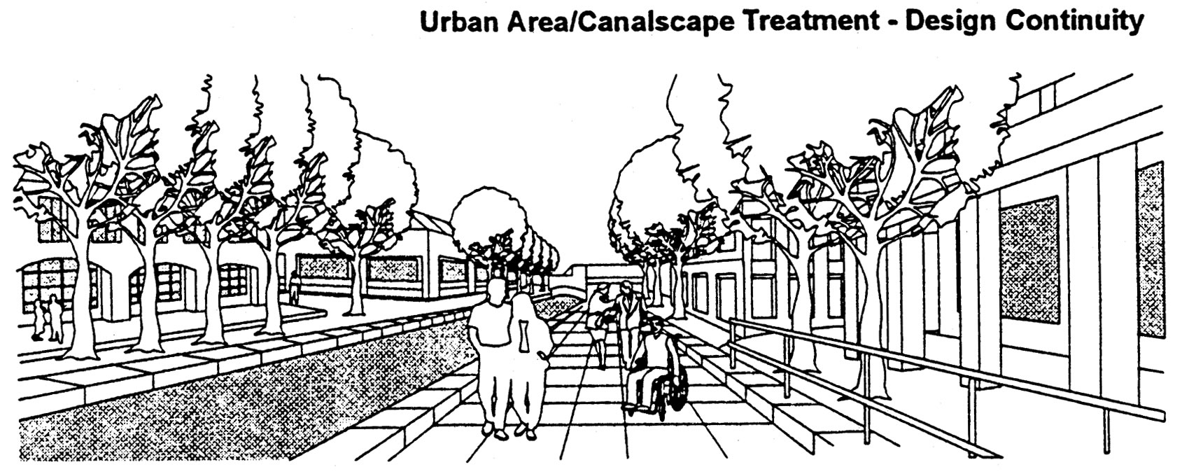
2.7.2. Canal bank right-of-way which is used for development in urban areas should be lighted at the pedestrian level at a minimum power of one (1) foot candle. Lighting fixtures on poles should not exceed fifteen (15) feet in height. (P)
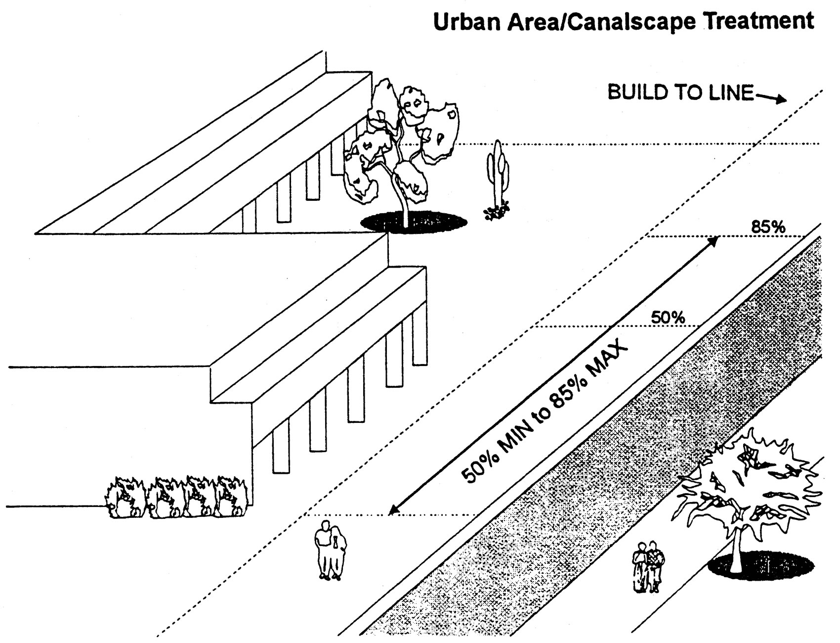
2.7.3. Buildings adjacent to the canal bank should be constructed along the canal right-of-way line ("build-to-line") or a distance of twenty-five (25) feet from the water’s edge (whichever is greater) for a minimum of fifty percent (50%) and a maximum of eighty-five percent (85%) of the building(s) canal facade. (P)
2.7.4. The area between the portion of the structure not constructed to the "build-to" line and the canal right-of-way should be a public or private pedestrian area with a hard surface including street furniture, functional planting, and other pedestrian amenities and may include a twelve (12) foot wide arcade. The hard surface should include stone, unit paver concrete, fired brick, or poured in place concrete. Other design characteristics of a pedestrian area should include outdoor furniture, shade structures to enhance pedestrian comfort, low-water use fountains to passively cool immediately adjacent outdoor areas, cool towers in appropriate areas, low water use shade tree bosque, lighting, and sloping to avoid drainage of storm water and runoff into the canals (P)
2.7.5. The ground floor arcade portion as described in 3.7.4 should contain a mix of pedestrian-oriented building uses. (C)
2.7.6. Buildings or portions of a building constructed on the "build-to" line should be stepped back a minimum of ten (10) for each floor above the first floor. (P)
Rationale (3.7.1-3.7.6): An urban area is an area which generates high levels of activity and has a strong pedestrian emphasis. Urban area land uses along the canal banks would include retail, restaurants, offices, resort/hotel, cultural facilities, and high density residential. The canal right-of-way should take on the characteristics of a highly developed urban paseo. Building design should help accommodate outdoor spaces for the pedestrian adjacent to the canals in an urban area. One of the goals in urban areas is to line the canal with activities that are of interest to the canal bunk users.
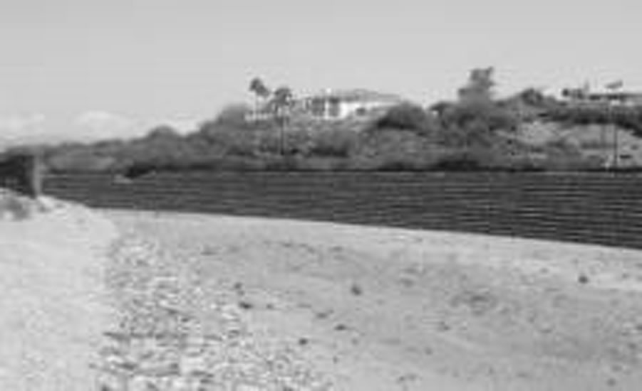
2.8. Suburban Area/Canalscape Treatment - Design Continuity. For purposes of this section, a suburban area shall be defined as one in which commercial, office, industrial, resort/hotel or public assembly development of less than four (4) stories or a floor area ratio less than 1.0, or residential development of less than twenty-five (25) dwelling units per acre abuts a canal bank.
2.8.1. Suburban areas of the canal right-of-way system should have the characteristics of a linear park. The design characteristics should include the following:
(A) Periodic public access points, as discussed in Guideline 7.1, physical accessibility, every 1/4 mile minimum; (P)
(B) Low water use plant materials when the canal right-of-way is landscaped. (P)
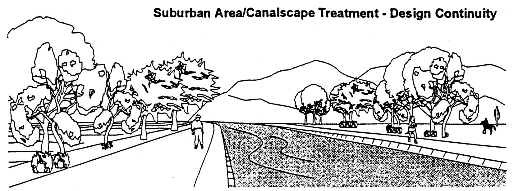
2.8.2. Design of the canal bank right-of-way should also include the following:
(A) Optional shade structures to enhance pedestrian comfort;
(B) A park-like system of multiple use trails. (C)
Rationale: A suburban area is an area which generates low levels of activity and which is sensitive to primarily adjacent residential land uses. A suburban area would include single family housing, parks, golf courses, and neighborhood retail uses.
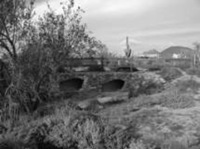
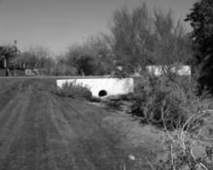
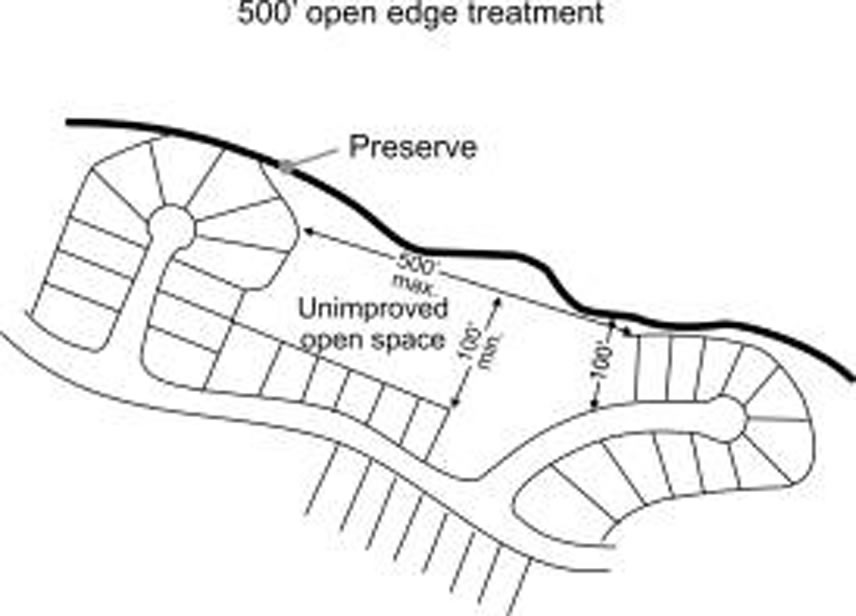
3. Sonoran Preserve Edge Treatment Guidelines. All property adjacent to the proposed or acquired Sonoran Preserve boundary having a minimum continuous common boundary of five hundred feet shall be subject to edge treatment.
3.3.2. Riprap should not be used at the Sonoran Preserve edge to mitigate drainage unless used with restraint and designed to blend with the desert setting through color, texture, soil plating, landscaping and other means. (P)
Rationale: Where engineered erosion control is necessary, a more natural looking drainage way will preserve the scenic qualities of the desert.
3.3.3. Where culverts are constructed, minimize the concrete while providing the opening required by the hydrology and to blend with the adjacent desert via materials and landscaping after construction. (P)
Rationale: Culverts can be visually obtrusive. Design can minimize visual impact by minimizing the concrete structure and blending materials and colors.
3.4.1. When separated from the Sonoran Preserve by an arterial or collector street, residential subdivision or commercial perimeter walls, and other walls should vary by a minimum of four feet every four hundred lineal feet to visually reflect a meandering or staggered setback. Design features should be used to break up the appearance of a long, straight wall. Such design features may include, but should not be limited to planters, decorative walls less than three feet in height, and dense landscaping adjacent to the wall to screen it. if design features other than meandering or staggered setbacks are used, the developer should demonstrate how the design visually breaks up long, straight wall appearance and the plan must be approved by the City. (P)
Rationale: Providing a variation in the appearance of a wall line through allowing the wall to meander or be offset or through another design feature will visually soften the edge of development adjacent to the preserve.
3.4.2. Walls and fences should be designed to blend into the desert environment by addressing the color, materials, and alignment of the structure. (P)
Rationale: Because straight lines rarely occur in nature, addressing the alignment as well as the color of walls and fences will help blend development into the desert setting.
3.5. Landscape Architecture.
3.5.1. Plants in public open space, public or private common areas, other than turf for active uses, or along public or private rights-of-way shall be from the approved plant species list (Appendix A). Palm trees and other plants specified on the prohibited plant species list (appendix B) shall not be allowed at trailheads, open spaces, or landscape setbacks adjacent to the Sonoran Preserve. (R)
Rationale: Sonoran desert plants would make an effective landscape statement or focal point that would reflect the Arizona Desert Southwest. Palm trees are not indigenous and are invasive; other non-native species also create problems in the desert environment.
3.5.2. All lot grading and construction areas shall be clearly marked by a chain link fence, an orange net fence with posts fifty feet on center, or an equivalent approved by the City, to minimize impact during construction. A sign shall be posted on the fence to make all parties involved in construction aware of the purpose of the fence. Construction fence is to remain intact until completion of construction. (R)
Rationale: Defining and containing the allowed grading area prevents overlap into areas designated for preservation. where disturbance must occur, the impact should be minimized.
3.6.1. Access points to the Sonoran Preserve shall be approved by the City. Construction of unauthorized access points shall not be allowed. (R)
Rationale: The parks and recreation department has specific needs and criteria for access points to open space areas that they manage.
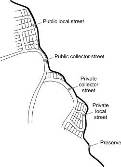
3.6.2. Public access, via a public collector or arterial street, or local street as approved by the City, for community or regional level use should be provided to a City developed and maintained trailhead or activity center within the Sonoran Preserve at approximately one per mile of linear edge, or as designated on the Sonoran Preserve Master Edge Plan. (P)
Rationale: The master edge plan or one mile standard will assure adequate public access to the substantial amount of Sonoran Preserve Land. Adequate public access is a necessary element to minimize impact within neighborhoods.
3.6.3. All residential development should provide a minimum of one unrestricted public access to a perimeter trail in the Sonoran Preserve for neighborhood use at a rate not to exceed four access points per mile of the Sonoran Preserve Edge, or as approved by the City. There shall be no required access points within a gated community except to serve the residents of such community and access points shall not be required within 100 feet of a gated community boundary. Site conditions may impact the exact location of the access point. The width of the access shall be a minimum of forty feet and a maximum of fifty feet. (P)
Rationale: Access to the Sonoran Preserve should be provided within easy walking distance for area residents. These access points also serve to reduce the demand for parking at primary and secondary trailheads.
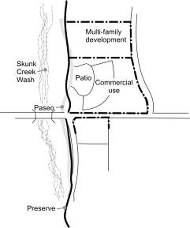
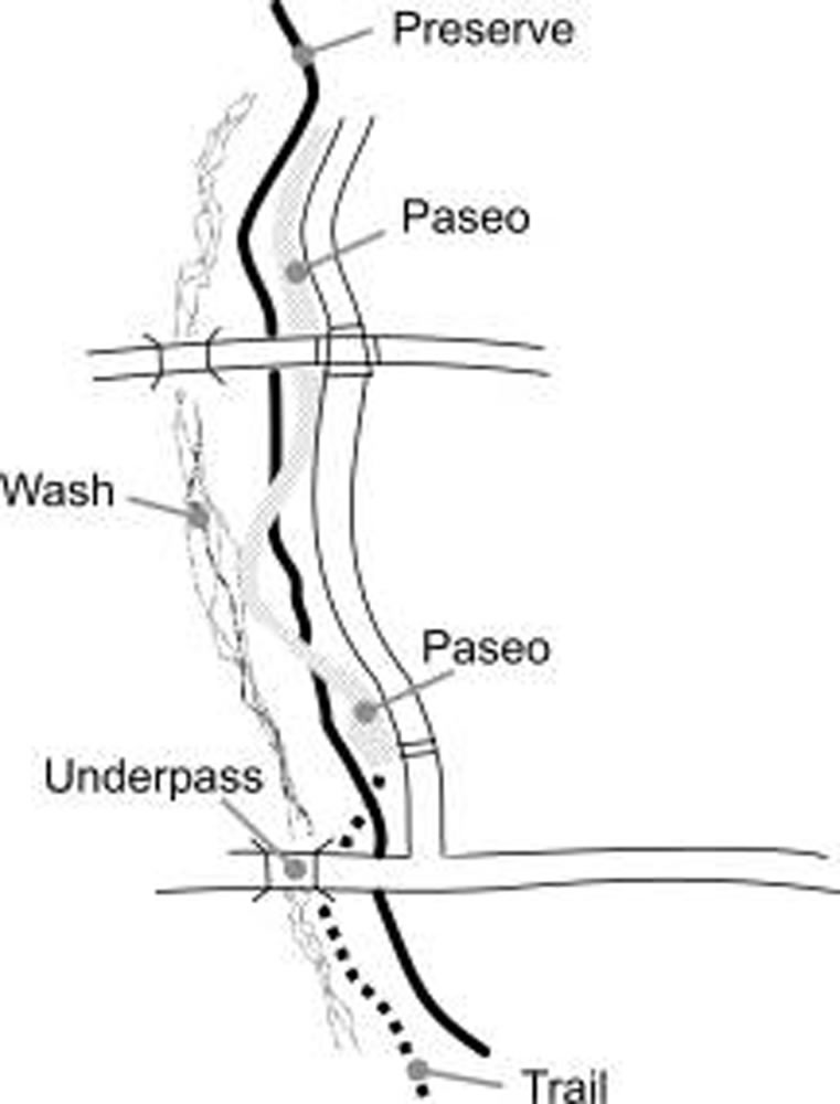
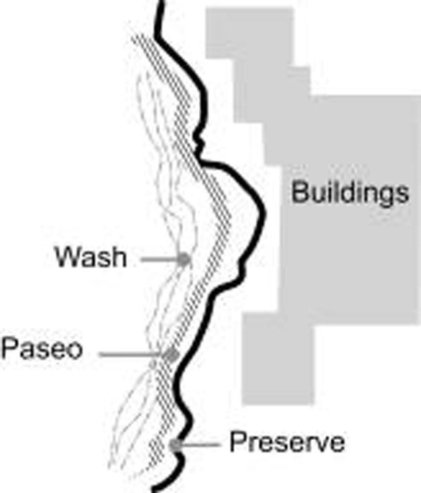
3.6.4. A paseo adjacent to the Sonoran Preserve or a Paseo adjacent to unimproved open space that is adjacent to a Sonoran Preserve Trail shall count as part of the required improved open space for a development provided the paseo provides public access as approved by the City. (P)
Rationale: In combination with providing an open edge treatment, paseos provide access and activity at the edge of the Sonoran Preserve.
3.7. Open Edge Treatment.
3.7.1. A minimum of sixty percent of the edge shall consist of open edge treatment. (R)
(A) Open edge treatment shall not include private undisturbed open space or public preserve which is less than 50' in width and less than 100' in depth. in these cases the edge boundary will be the shortest distance between two points of private improvements.
Rationale: Sonoran preserve is purchased with public funds to serve as a visual and recreational amenity for all. The 60% edge is consistent with the voter approved general plan 2002 to provide adequate visual & physical access to the public land.
3.7.2. The open edge treatment may be shown on an individual project basis, in conjunction with a Planned Community District (PCD), or in an approved functional unit edge treatment plan. A master open edge treatment plan submitted in conjunction with a Planned Community District (PCD) or a functional unit of a PCD should verify that the required percentage of edge treatment is provided based on the overall master development rather than by parcel. The master open edge treatment plan allows the incorporation of facilities and open space available to the public, such as parks, schools, recreational facilities and retention areas, as long as the overall required percentage of edge treatment is reasonably dispersed throughout the PCD as approved by the City. (P)
Rationale: Open edge treatment encourages the sense of ownership of the Sonoran Preserve from the greater community, rather than only those located at the edge. Facilities such as parks, schools, recreational facilities and retention areas allow both visual and physical access to the preserve. typically, these are separate parcels, where they would provide no edge credit to developers. By allowing them to be included in a master plan for open edge treatment, siting at the edge is encouraged.
MASTER EDGE PLAN COMBINES EDGE TREATMENT ON DIFFERENT PARCELS
3.7.3. In development adjacent to the Sonoran Preserve Edge, open edge treatments shall be used on the required edge in accordance with the following table (P):
(4) Municipal facilities. Municipal facilities such as a fire station, or police station, community center, or library may be designed to provide visual or physical access to the Sonoran Preserve for the public.
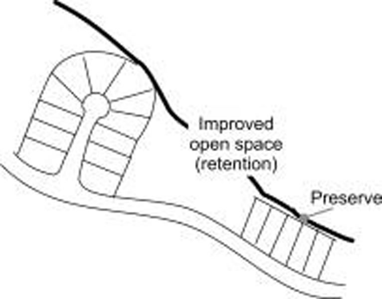
(5) Private undisturbed open space. Private undisturbed open space, a minimum of 50 feet in width and a minimum of 100 feet in length.
(6) Private improved open space. Private improved open space located between the Sonoran Preserve or undisturbed open space and an adjacent street. Private improved open spaces provide a connection to public open spaces and may serve necessary purposes, such as retention.
Adjacent Open Space May Be Unimproved Or Improved
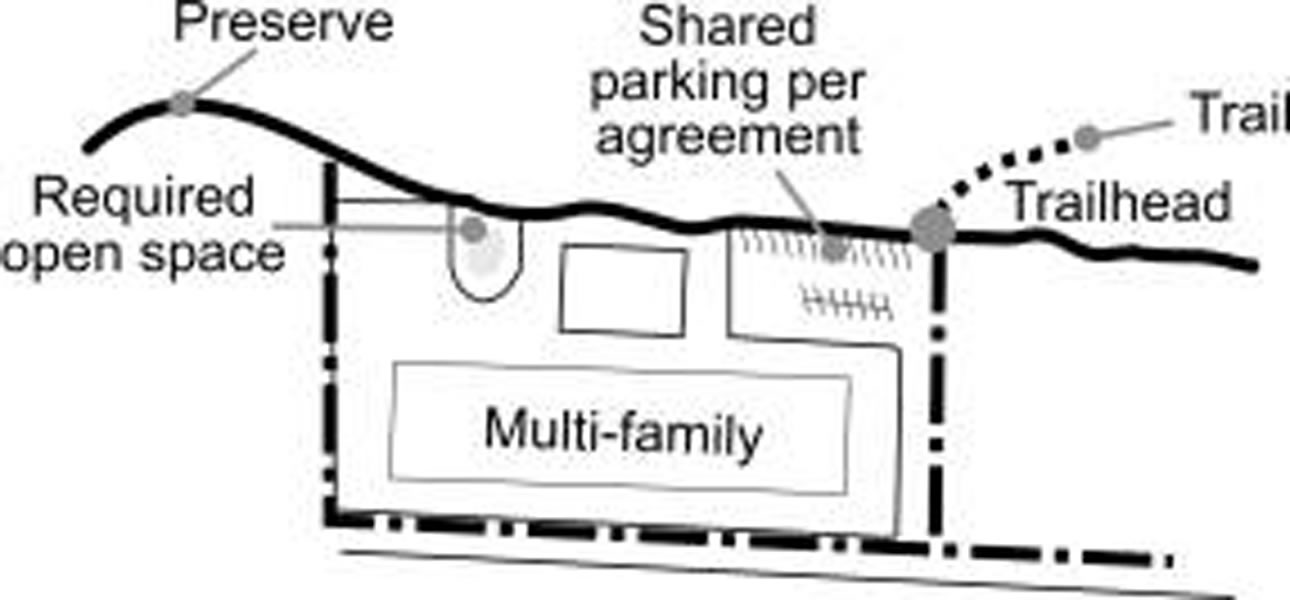
(7) Public school. Public schools may provide visual access to the Sonoran Preserve for the public, and may be designed to also provide physical access to the preserve for the public.
(8) Shared parking. Shared parking, as approved by the City, may count toward open edge treatment if it is shared public parking. Shared parking provides a public benefit, but is subject to a joint use agreement developed with the City.
Shared parking is per joint use agreement.
(9) Public street "T" intersection. Where a public street enters a "T" intersection such that an area the width of the street is maintained as undisturbed open space between the street and the Sonoran Preserve that street width should be considered open edge treatment. A "T" intersection provides visual access for the public to the preserve from the developed side of the edge.
Public and private streets may be used, per Table 2.
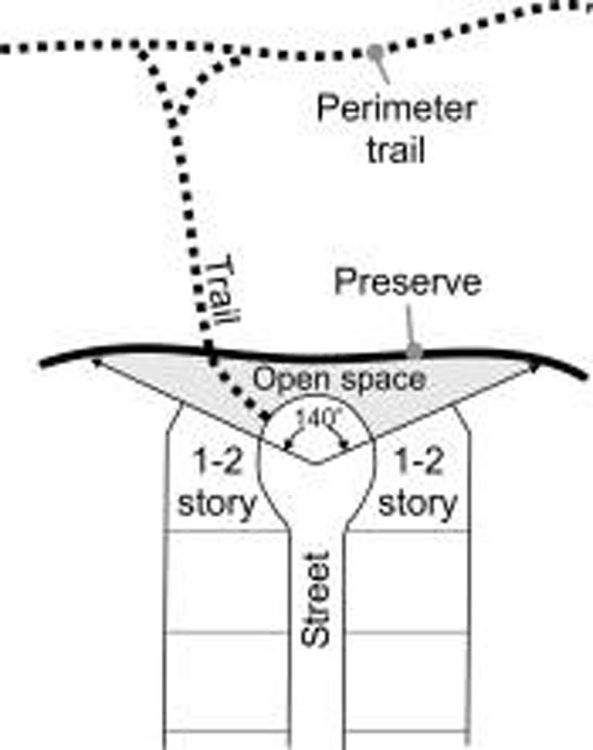
(10) Public street cul-de-sac. Within a single family development, a street cul-de-sac design provides public visual or physical access to the Sonoran Preserve per a plan approved by the City, with a minimum width of the open space connection defined by a line running along the public or private preserve open space edge connecting the rays of a one hundred forty degree angle measured from the center of the cul-de-sac. Culs-de-sac that open on to the preserve frequently provide visual access for the length of the cul-de-sac and passing streets.
(11) Retention or detention basin. A retention or detention basin, graded to blend with adjacent terrain, provides a visual and physical opening to the Sonoran Preserve, as well as serving drainage functions.
(12) A single loaded private street. Single loaded private streets allow daily access, even if primarily visual. Private single loaded roadways provide access to residents of a development, rather than the greater public.
(13) Private street cul-de-sac. Within a private development, a street cul-de-sac design provides visual or physical access for the residents to the Sonoran Preserve per a plan approved by the City, with a minimum width of the open space connection defined by a line running along the public or private preserve open space edge connecting the rays of a one hundred forty degree angle measured from the center of the cul-de-sac.
(14) Private street "T" intersection. Where a private street enters a "T" intersection such that an area the width of the street is maintained as undisturbed open space between the street and the Sonoran Preserve that street width should be considered open edge treatment. A "T" intersection provides visual access for the residents of a subdivision to the preserve from the developed side of the edge.
Wash Corridors Provide A Connection To The Preserve
(15) Creative option. An equivalent creative alternative as approved by the City that reflects diversity, together with visual and physical access.
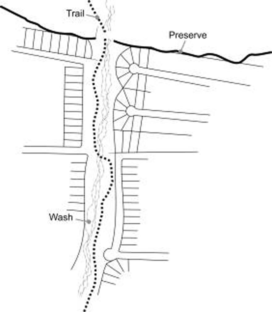
(A) Wash corridor credit. Wash corridors a minimum of 100 feet in width and not to exceed a length of five hundred feet that penetrate the edge of the Sonoran Preserve shall be considered open edge treatment as follows:
Rationale: Single-loaded streets, when abutting the preserve’s edge, shall have a unique design. A meandering road that follows the wash form or preserve edge reduces vehicular speed and allows for interesting views into the preserve.
3.9.1. In multi-family development no private parking except shared parking shall be located within fifty feet of the Sonoran Preserve or private undisturbed open space. (R)
Rationale: The visual impact of a parking lot should not decrease the enjoyment of public or private undisturbed areas for residents.
3.9.2. If units are within fifty feet of the Sonoran Preserve Edge, development shall be designed so that a minimum of fifty percent of residential units adjacent to preserve open space shall face on to, or provide balconies or patios adjacent to the Sonoran Preserve. (R)
Rationale: Development contiguous to the Sonoran Preserve or private undisturbed areas will be able to take advantage of the view afforded by open space, as well as provide informal monitoring of activity in the area.
3.9.3. Multi-family development within twenty five feet of the Sonoran Preserve edge shall be limited to two stories or thirty feet in height from finished floor. One foot of additional height shall be allowed for every two feet additional setback from the preserve edge. (R)
Multiple Stories Are Stepped Back In Height
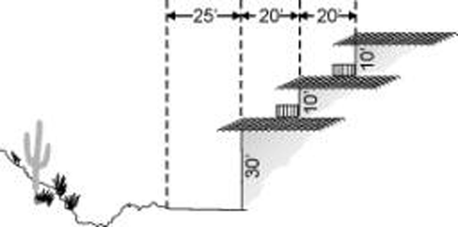
Rationale: The height limit adjacent to the edge opens views into the Sonoran Preserve.
3.9.4. In multi-family development adjacent to Sonoran Preserve or adjacent private undisturbed open space, a minimum of fifty percent of the required improved private open space should be located adjacent to the preserve edge. (P)
Rationale: Providing the improved open space for development adjacent to the Sonoran Preserve or undisturbed open space will allow access to the Sonoran Preserve for all residents within the development and encourage activity to or within the preserve areas.
3.9.5. The edge of improved open space contiguous to the Sonoran Preserve edge shall be approximately equal in width and depth, and a minimum of thirty feet and an average of not less than fifty feet. (P)
Rationale: The size of the open space at the Sonoran Preserve Edge should not be too small in width or length to be used by residents.
3.9.6. All perimeter fences or walls adjacent to the Sonoran Preserve or undisturbed private open space shall be view fencing or low seat walls. (R)
Rationale: Solid fencing or high walls block views, which are an amenity for the residents and also provide for informal monitoring of open space. In multi-family developments, privacy walls may be built around patios.
3.10. Single Family.
3.10.1. Lots that back up or side on to the Sonoran preserve edge shall accommodate drainage and necessary maintenance access on private land, as approved by the City. (R)
Rationale: Access for private drainage and maintenance of drainage areas for private developments should not be on public land.
3.10.2. Lots with two or more sides abutting undisturbed open space shall be designed with obtuse angles, rather than right angles or acute angles, to avoid sharp corners or sudden narrowing of connecting open space. (R)
Acute Angles Restrict While Obtuse Angles Open Development Into Open Space
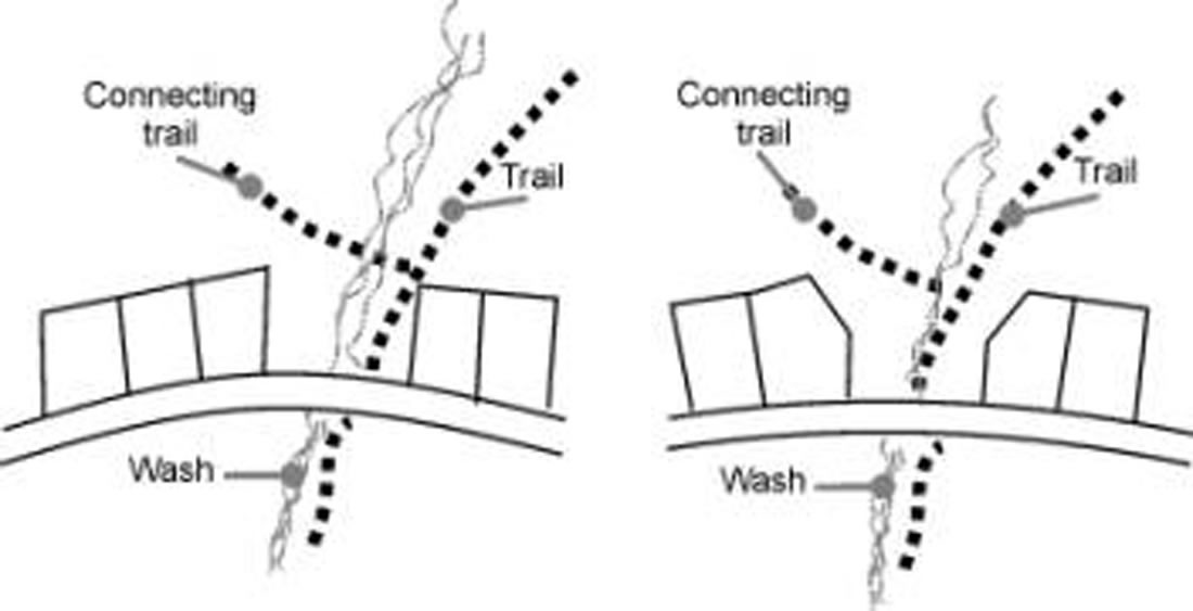
Rationale: The angles will produce a gradual narrowing from the adjacent open space leading into the corridors. This will better blend development with the environment, minimize sudden constrictions, and provide better views.
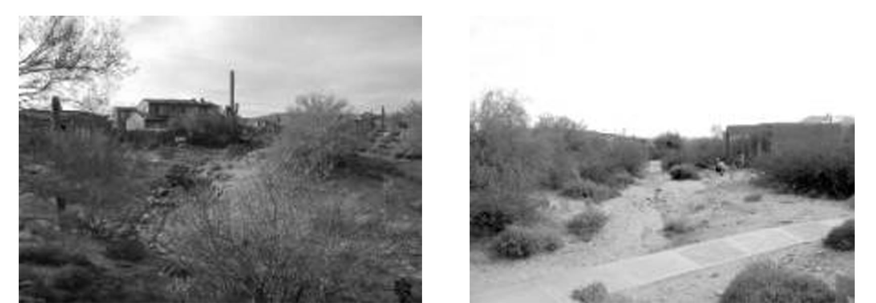
3.10.3. Along undisturbed open space, where a building envelope is not used, not more than fifty percent of the homes shall have a building height greater than one story or twenty four feet measured to top of the parapet or the top of the ridge on sloping roofs. Where building envelopes are used, there is no restriction on the number of homes greater than one story, except regardless of lot grading, no more than two homes above one-story, or twenty-four feet may be adjacent to one another. (R)
Rationale: For view preservation and to blend into the desert environment, buildings must maintain a low single-story profile to be in character with adjacent Sonoran Desert vegetation which generally reaches a mature height of approximately twenty two to twenty five feet. By maintaining a lower building height the sense of open space will be enhanced.
Single-Story Homes Blend With Low Profile Desert Vegetation Better Than Two-Story Units
3.11. Single family—Low Density Residential (Lots Of Eighteen Thousand Square Feet or More).
3.11.1. On Non-Hillside Lots Adjacent to the Sonoran Preserve Edge, all improvements, including driveways, landscaping, and underground utilities, shall be located within a building envelope, occupying no more than fifty percent of the lot up to a maximum of twenty thousand square feet area of the lot area, whichever is less. (R)
Rationale: By establishing a building envelope, a portion of each lot is preserved and the character of the area is maintained, which creates value for all the residents.
3.11.2. The building envelopes may require greater setbacks than the minimum required by ordinance to maintain site features in an undisturbed condition, such as rock outcroppings, significant stands of vegetation, or specimen trees or saguaros. The minimum setbacks defined in this ordinance are not grounds for any increases in the size of the buildings envelope. Lots to be developed with building envelopes should be designated as preservation lots (PSV) on the site plan, final subdivision plat, or lot split. Areas outside of the building envelope are to remain permanent undisturbed open space and to be designated as such on all plans submitted to the City. (P)
Rationale: The native Sonoran Desert is the major component forming the identity of this north area and therefore is to be maintained in an undisturbed condition when advantageous.
3.11.3. Individual lot grading plans shall be submitted for review and approval by the City for lots eighteen thousand square feet and larger. Vegetation and topographical features, such as specimen plants, washes and rock outcroppings, are to be identified on the plans. (R)
Rationale: Individual grading plans showing topographical features will assist the builder and City plan reviewers in identifying key natural features on a site to be preserved.
3.12. Commercial Buildings Adjacent To Preserve.
3.12.1. Commercial uses adjacent to the Sonoran Preserve, regardless of its size, should vary the building mass by varying the setbacks of the building planes to articulate and mimic the form and treatment of the preserve edge at the particular location. (P)
Rationale: Commercial uses should complement the natural edge of the Sonoran Preserve. Buildings should be massed to allow the built form to reflect the irregular natural land forms.
3.12.2. Commercial uses adjacent to the Sonoran Preserve should include public pedestrian access through the site to the public open space and connected to designated trailheads per the approved Sonoran Preserve Master Edge Plan. Design for access to the Sonoran Preserve at all locations should be approved by the City. (P)
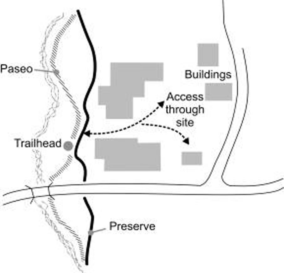
Rationale: Access to the Sonoran Preserve must be planned at specific points through developed sites in order to prevent spider trails into the preserve area, as well as provide for control and safety at entrances to adjacent commercial development.
3.12.3. Commercial uses adjacent to the Sonoran Preserve should enhance the enjoyment and take advantage of proximity to the preserve by:
(A) Providing for outdoor uses to allow enjoyment of the Sonoran Preserve, such as restaurants with outdoor patios, employee lunch or break areas, and recreation based businesses, such as bike or roller blade rentals, located between buildings and preserve.
(B) Providing adequate open space between buildings to provide views into the Sonoran Preserve.
(C) Where parking is within seventy feet of the Sonoran Preserve Edge or paseo, design parking in small groupings of less than fifty cars, separated by pedestrian pathways of material other than asphalt, and shaded, to provide easily identifiable and accessible connections to the paseo and preserve. (P)
Rationale: Commercial uses located at the edge of the Sonoran Preserve can take advantage of proximity to preserve areas as well as provide safety through informal monitoring of such public spaces. Outdoor uses provide an amenity for employees as well as customers.
3.12.4. Service areas contiguous to Sonoran Preserve or private undisturbed open space areas are not allowed. All refuse and service areas must be separated from the preserve by parking or a circulation/service driveway and screened from views of abutting streets or the preserve with decorative walls and landscaping. (R)
Rationale: For the appropriate blending of the Sonoran Preserve with the built environment, service and refuse areas must not be visible from the preserve edge. Where service areas might be visible, the appropriate buffering and design of the loading, refuse, or service area will mitigate the effect of the service area on adjacent preserve.
3.12.5. Projects adjacent to the Sonoran Preserve Edge should provide shared or joint use of parking with other projects to facilitate accessibility to the preserve as approved by the City. (P)
Rationale: The provision of parking with easy access to the preserve will attract people that not only use the Sonoran Preserve but they can also be potential customers for commercial sites. The sharing of parking allows a more efficient use of parking in adjacent projects as parking loads distribute evenly depending on the different land uses.
3.12.6. Parking adjacent to the Sonoran preserve edge shall be limited to ten percent above the minimum required by ordinance, except:
(A) An additional five percent is allowed for a pedestrian pathway a minimum length of one hundred feet provided across the parking lot to the preserve or paseo, when the pathway is a material other than asphalt, fifty percent shaded, and on addition to required perimeter sidewalks or multi-use trails, or
(B) An additional five percent above the minimum required parking if landscaped planters are provided every fifty feet (approximately every five parking spaces). (R)
Rationale: The visual impact and heat gain from parking lots in proximity to the Sonoran Preserve should be minimized. Where parking lots are close to the preserve, it should not be unpleasant to cross the parking lot to access the preserve.
Appendix A: Approved Plant Species List for Sonoran Preserve Edge Treatment Guidelines